
Mobile scanner game changer for forestry management
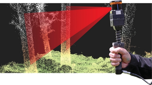
The hand held scanner provides highly detailed 3D data of individual trees within a stand where GPS is unavailable.

A small, lightweight mobile laser scanning device is proving a boon for forestry resource management.
Successful trials of the ZEB1 hand held scanner by Scion’s Forest Systems staff has demonstrated the means to accurately locate and measure the lower stems of individual trees in more detail than is possible using aerial LiDAR (Light Detection and Radar).
The ZEB1, developed by UK-based company 3D Laser Mapping, has the ability to scan and provide spatial locations for individual trees within a stand where GPS is not available. When comparing this to current terrestrial laser scanning technology, research leader Dave Pont says the device is a game changer for the forestry industry.
“The device is lightweight - less than one kilogram – and scans quickly while the operator is ‘on the go’ allowing an inventory plot to be completed in a fraction of the time it takes for a conventional terrestrial scan to be done,” explains Dave.
“In the forest, trees are obscured by terrain and other trees, and conventional tripod mounted units need to take multiple scans to compensate for this. The ZEB1 scans continuously as you move, providing a single, highly detailed point cloud from the external surface of the scanned objects. Being hand held, it can also be used on rough terrain or anywhere that is accessible and safe for the operator. The device’s portability and continuous scanning overcomes the issue of other trees obscuring the field of view.”
The novel SLAM, or Simultaneous Localisation and Mapping, technology behind ZEB1 is based on sophisticated algorithms that generate a point cloud, or a set of 3D data points. These data can then be used to generate such things as 3D models or visualisation. In this instance, the prototype analysis method developed by our research team to extract information from the point cloud has provided valuable information about the lower stems of individual trees. On pruned trees it measures such things as pruned height, stem straightness, taper and lean. When combined with an aerial LiDAR assessment of the canopy, it may therefore be possible for inventory plots to be scanned and characterised in detail for management purposes, accurately, quickly and considerably more cost effectively.
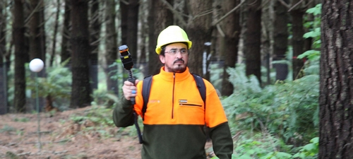
The device scans quickly while operator Rodrigo Osorio is 'on the go'.
For Dave and other research teams at Scion, the mobile device shows real potential to have practical applications in forestry and to facilitate research within Scion’s Growing Confidence in Forestry’s Future programme. Dave is currently working with the Informatics Team to further develop our in-house capability for processing the point cloud data.
“For example, it’s possible the device could be used to capture the external shape of tree stems and the surrounding environment before harvest, then use our new destructive sampling technology to relate these data to the tree’s internal wood qualities,” says Dave.
“We are also investigating its application in characterising productivity and genetics, scanning for post-harvest debris and in remote sensing tree health, plus its potential use in forestry activities such as scanning logs on skids and trucks”.
For further information
Contact Show email