When the rain pours, where does the water flow?

Extreme weather events are becoming more commonplace. Knowing where the water is, where it is going, and who gets to use it are the three main questions Forest Flows researchers aim to answer.
Now more than ever, New Zealanders are looking for answers about the environment we live in. How do we utilise our natural resources in the most sustainable way in the face of a changing climate? Water is one of our most precious taonga and this resource is increasingly put under pressure due to climate change and land-use intensification. The MBIE Endeavour-funded Forest Flows research programme is investigating how we can create and maintain water-resilient landscapes to provide beneficial outcomes to all New Zealanders.
Preliminary insights
The research programme is in its fourth year and preliminary results from recent storm events are now available. Scion’s Forest Flows programme leader and senior scientist, Dean Meason, in collaboration with NIWA, analysed data from the Auckland Anniversary weekend flood event.
“The Forest Flows programme provides ground-breaking new insights of extreme weather events on planted forests.
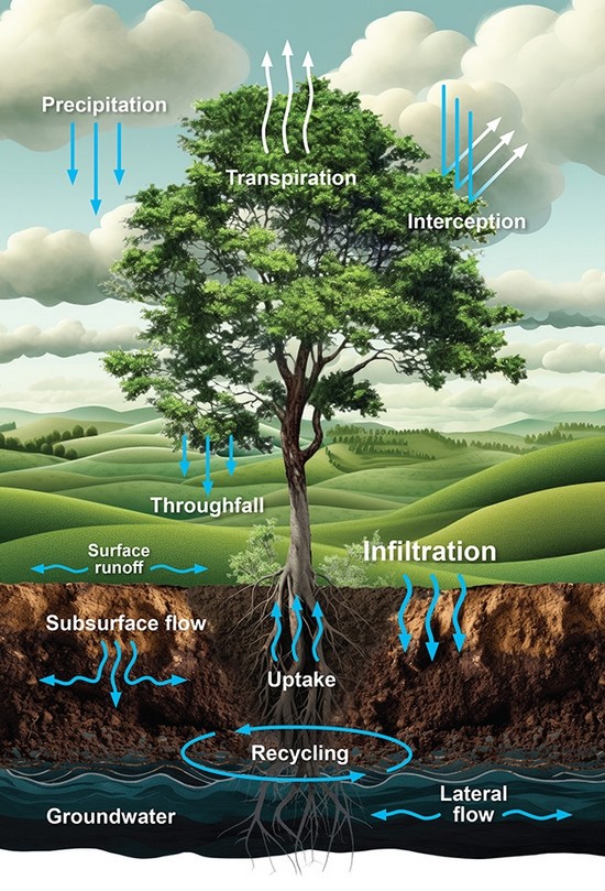
“Data from the ground-based sensor networks has provided, for the first time, direct measurements in unprecedented detail from sensors continuously recording data at five-minute intervals.” Rainfall, soil moisture, stream flow and groundwater recordings have been used to create a picture of where the water went during and after these storm events.
Forest Flows data is well-positioned to answer post-cyclone Gabrielle questions. Two of the primary research catchment areas, located in Mahurangi Forest in the Auckland region and Titoki Forest in the Tararua district, experienced the worst of the recent storm events in 2023 and this data is still being analysed. Despite extraordinary levels of rainfall over 60 hours at Auckland Anniversary weekend, and although the soil is shallow at the Mahurangi (229mm) and Titoki sites, it didn’t reach saturation point.
Despite extraordinary levels of rainfall over 60 hours at Auckland Anniversary weekend, and although the soil is shallow at the Mahurangi (229mm) and Titoki sites, it didn’t reach saturation point.
“This means that almost all the rainfall that reached the ground directly infiltrated into the soil and most of the rainfall did not move directly to the stream,” Meason says.
These small research sites are on erodible soils in planted forest catchments of radiata pine but are representative of much larger areas. Inspection of these sites showed little evidence of small-to-medium hillslope failures (slips) and woody debris movement off side slopes.
“This research will help to identify markers for sites that are vulnerable to hillslope failure and could be applied to other forests,” Meason says. “An improved understanding of the site conditions that trigger flash floods from forested catchments and what could be done to mitigate it will support decision-making.”
Karen Lucich, spokesperson at Summit Forests appreciates the effort Scion and partners are putting into Te Hiku Forest to gain greater understanding of water movement and availability.
“The forest achieved its original goal of providing employment and stabilising the sand, after the indigenous vegetation was removed. As values evolve and we strive to improve land use practices it’s essential to have sound knowledge to base decisions on. This research will give a greater understanding of the whenua.”
Digital twin – pulse of the forest
The intensive Forest Flows wireless sensor networks cover 10 forest research sites around the country and capture millions of data points each year. A total of 1717 sensors record information about soil moisture, tree canopy water stress, rainfall, water age, stream flow, tree growth and water use, plus many more. Real-time data from Scion’s sensor networks, NIWA meteorological stations and remote sensing data from the University of Auckland and XERRA together provide a worldleading picture of the hydrological processes occurring within planted forests.
Digital twins have been used in other industries, such as the manufacturing industry, however a virtual copy of forest environments in a forest management setting is novel. Forest Flows data enables a forest digital twin model to be built, which will connect and integrate the different data from various sources. This breakthrough new biophysical hydrology model of the forest provides capability for cutting-edge analysis and modelling tools to understand how planted forested catchments respond to extreme storm events and other less extreme climatic conditions. The model will be able to predict what happens in a forested environment across different soils and geology throughout New Zealand, identify correlations and forecast for a wide variety of scenarios, enhanced by machine learning and artificial intelligence.
Collaboration
Answering the last question of the Forest Flows programme, ‘Who gets to use the water?’ is arguably the most challenging. Scion’s research group leader of Economy and Society, Dr Grace Villamor, has undertaken virtual and in-person workshops, engaging with farmers, foresters, iwi, non-government organisations (NGOs), local councils and other interested community groups to find out what is most valuable to them. Views on water, trees and planted forests were collected, as well as views on how informed these groups feel. Earlier stakeholder engagement in 2022 highlighted the importance these groups placed on conservation of streams and rivers for future generations.
“In this research drought was perceived to be the main environmental risk. It will be interesting to see in upcoming workshops, movement in peoples’ views and concerns over time,” Villamor says.
Gleaning this insight helps Scion to tailor research outcomes for interested parties based on need.
What’s next?
The research teams are busy analysing the large amount of data collected so far. The programme plans to share first results with local communities in late 2023 and use this feedback to inform further engagement.
“Regular and active engagement with our communities throughout the final year will help us convey the most meaningful research insights – each group has different values and requirements for information. Rather than dictating what results we believe are important, we seek to understand what is important and valuable to the community and provide them with the answers that they seek”, Villamor says.
Forest Flows programme is a collaboration of 13 local and international institutes, universities, and industry partners. MBIE contributed $13.7 million in funding from the Endeavour Fund.
For more information, please contact Dean Meason.