
New ways to measure and value small forests
In particular, Jonathan is referring to the amount of data needed to accurately estimate forest yields. In larger forests (with more uniform topography, management, and crop conditions), fewer measurements are needed per hectare compared with smaller forests. In part, this is because smaller plantations tend to be located on more variable terrain and have less consistent tree growth and stand management. This means that more sample plots are needed per hectare to achieve accurate results, which comes at a cost to the forest grower. Accurately estimating forest yields is important in gauging the current and future wood availability at regional and national levels, as well as for providing realistic forest valuations.
To address this, a project team led by Jonathan, is developing techniques for gathering data specifically for smaller forests. The three streams of this project include developing UAV (unmanned aerial vehicles, also referred to as drones) based methods, calibrating existing national forest yield models with local calibration plots and community data sharing.
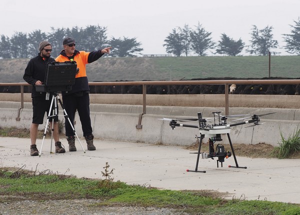
UAV science applied to small forests
The team is tasked with creating new statistical methods to use UAV data for small areas and incorporating that information with field plot data to improve forest yield estimates.
UAVs are a new technology that are now providing opportunities for collection of new types of data. If useful analysis techniques can be developed, this could represent a significant opportunity to improve assessment of small-plantations and woodlots more accurately.
Currently, small-forest growers can only improve accuracy by taking more measurements, or they can take the risk that a small number of sample plots will yield adequate results. The team aims to make the measurement process more efficient and take away some of the uncertainty in the measurement of smaller forests.
Once complete, this research will have identified how much field data collection is necessary in combination with other tools, to create efficient and accurate yield estimates.
Calibrating national models
Research efforts also include increasing the applicability of existing national scale yield models so that they work better for small-plantations and woodlots.
The team is investigating whether it is possible to use a small number of field plots to calibrate an existing national model developed by Scion’s senior scientist Michael Watt and his team. If successful, this project will make a widely available tool valuable to more forest owners and increase the uptake and reuse of data and models developed through previous research.
Data sharing for small forest owners
As the largest forest growing group in New Zealand, the potential for data sharing between small-forest growers could prove very valuable. In particular, forest growers could contribute their existing forest measurement data into a shared database, making it available for others.
Jonathan explains, “We are working on a prototype data sharing platform to bring together forest information and publicly available remotely sensed data sets. Then we’ll develop software that extracts the information from the database, and builds models of forest yields that can be applied and summarised for relevant forest areas.”
Building a successful database relies on finding participants willing to share their data. Jonathan and the team will be working with forest management and consulting companies to reach out to small-forest owners, so you may hear from them. If you are interested in contributing to this research and becoming part of a community of users, the team is eager for volunteers. All data can be made anonymous if required, please get in touch if you would like to be involved.
This two-year project is now half way through. The research results will be presented at industry-related events and seminars and published in 2018. The work has been supported by AgMardt, Forest Growers Levy Trust, New Zealand Farm Forestry Association, and the Neil Barr Foundation.
Video: Improving small woodlot and plantation inventories
Watch a drone/UAV flyover a small woodlot and see how the LiDAR data collection works. 1min 50sec.