Geospatial & bioinformation technologies
Integrating layers of data related to the people, places, environment and processes of forest into practical management tools is one area of our research.
Our team of ecologists, and geospatial and environmental analysts use Geographic Information Systems (GIS) to spatially analyse and visualise data from a variety of sources, such as aerial photographs, hyperspectral imagery and LiDAR.
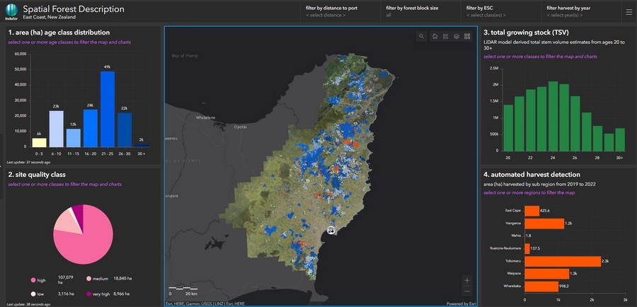
Geospatial tools add value to existing data and statistical models. We can create models that give results across a land surface, allowing more powerful insights than graphs or empirical results. Dozens of map surfaces can be created for a single forest stand or for New Zealand as a whole. Each surface (or layer of information) can be turned on or off to explore relationships between data (for example, mean air temperature and wood density).
Bioinformatics is the science of managing and mining genomic data sets.
Remote Sensing
Remote sensing techniques allow us to acquire data from a distance. Some of the options we are using include:
- LiDAR
- Satellite data
- Multi-spectra
- Video/photos
The challenge is how to make best use of these new data to augment or replace existing forest resource assessment procedures and improve efficiency of forest valuation. Some of the uses we are exploring include:
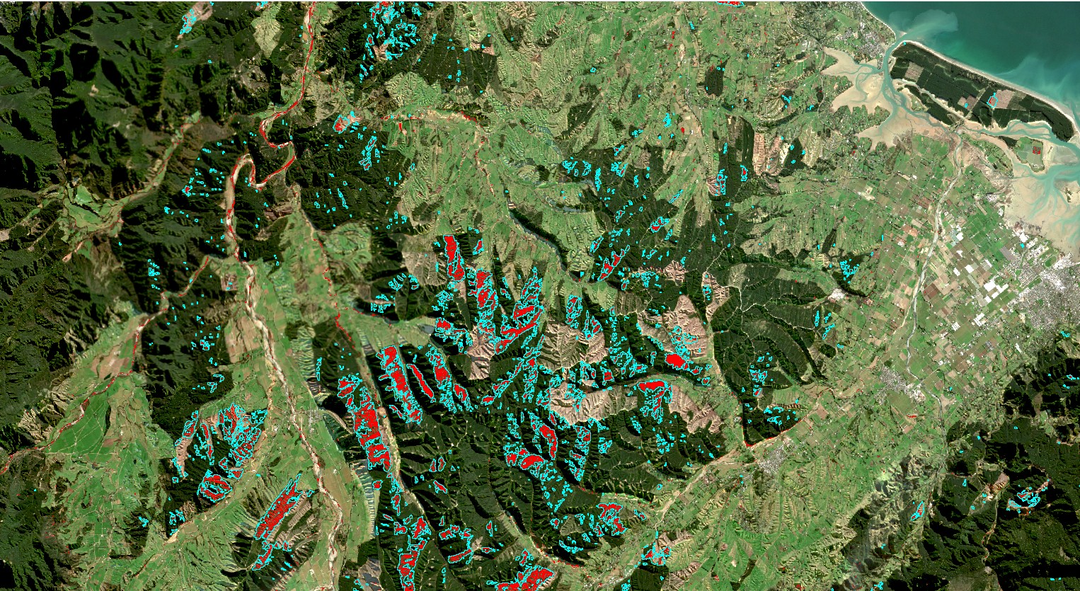
- Aerial imaging of cutover areas, with the potential for automated delineation and mapping of harvested areas
- High resolution imagery to assess survival rate following planting
- Use of image-based point clouds to derive canopy heights and terrain models as a low cost alternative to LiDAR
Contact
Data and Geospatial Intelligence: Elizaveta Graevskaya, Research Group Leader
Remote Sensing and GIS: Michael Watt, Portfolio Leader - New Value Digital Forests; Principal Scientist
Unmanned aerial vehicles
Scion has invested in advanced unmanned aerial vehicles (UAVs), which can be used to collect LiDAR data, multi-spectral imagery and hi-definition video.
We are now developing the software and systems to translate these data into useful information for forest managers. Our focus is on identifying technologies that can add value to the forest industry, and on developing easy-to-use and robust algorithms and tools for forest managers.
These include:
- Comparisons between data from lower cost image-based point clouds and higher cost LiDAR point clouds
- Assessing the viability of UAV platforms to collect LiDAR / imagery over discontinuous forest resources not suited to conventional fixed-wing campaigns
- Monitoring contractor performance
- Monitoring and documenting environmental impacts and performance of harvest operations
- Loss assessment and planning for value recovery after catastrophic weather events
Our investment in equipment and research presents an opportunity for industry partners to work with Scion in identifying, testing, and evaluating these technologies.
Contact
Peter Massam, Team Lead, Autonomous Systems and UAV Operations Manager
Kevin Park, Autonomous Systems Specialist Team Lead
Robin Hartley, Scientist, Autonomous Systems
- Visit the Tools for Foresters website
Software solutions
Scion’s software, modelling systems and decision support tools harness data from over 70 years of forest science and management research.
Examples include:
- Permanent Sample Plot (PSP) system: a comprehensive database containing over 40 years of growth data from 30,000 plots located in forests throughout New Zealand.
- Empirical growth and yield models for forest planning and forecasting purposes.
- Models showing the variation in productivity and its drivers across New Zealand.