Satellite imagery aids forest management
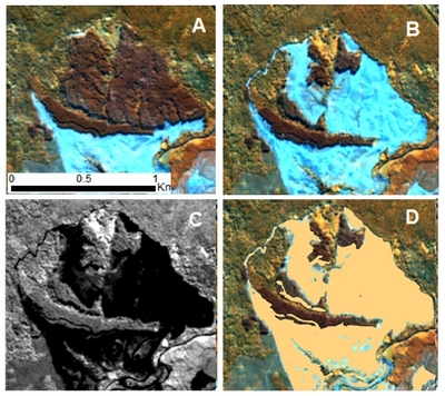
Time series showing detection of harvesting using RapidEye imagery. Shown are the (A) stocked area, (B) the same area following harvesting, (C) EVI imagery of the harvested area and (D) the GIS representation of the harvested area.
Satellite imagery is proving an effective tool that meets forestry management and research needs for cost effective, up-to-date information on the status of forest resources.
A collaboration between Scion and industry consulting company Indufor Asia-Pacific Ltd has enabled Rayonier Matariki Forests to use satellite imagery to assist with forest management.
“The project demonstrated that RapidEye satellite imagery can be used to identify new harvest areas, delineate stands, and gaps within stands, such as wind-throw areas and erosion,” says Philip Elworthy, Forest Services Manager at Rayonier New Zealand Ltd.
Mr Elworthy adds that while RapidEye satellite imagery is becoming a valuable tool for forest management, its real power will be realised when data are incorporated in GIS-ready tools or used in combination with traditional aerial photography.
RapidEye is a German-based company that owns a constellation of five identical satellites circling the globe daily with each producing high resolution imagery. Given its near-continuous global coverage, forest managers have access to a vast archive of imagery via an online search tool. An area 70 by 70 km is able to be imaged in one satellite pass at a cost of about NZ $1.50 per km2 (or 1.5 cents per ha). The image resolution at 5 metres is high enough to map resources at a 1: 25000 scale.
Targets on the ground, such as trees, bare earth and leaves reflect light in different well-known wavelengths. Light reflected by chlorophyll from healthy trees is in the 400 to 750 nanometre (nm) wavelength range. Changes in reflectance values in the 750 to 850 nm range indicate aged or stressed leaves and can be an indicator of disease or a sign of limiting environmental factors such as water shortage or nutrient deficiencies.
Overseas, satellite technology has been used for updating national forest inventories, monitoring deforestation and harvesting rates, fire risk, wind damage and plantation establishment.
With increased data available over large areas, satellite imagery may prove to be a boon for forest researchers. Already, Scion’s resource assessment project leader Dr Michael Watt in collaboration with industry has completed a number of studies using satellite imagery to give insights into radiata pine forest growth in New Zealand. In one study, detecting the reflectance of trees until canopy closure (typically seven years) should be able to provide a reliable assessment of how successfully large stands have established.
He suggests that the variability of reflectance response across stands is able to highlight differences in growth and therefore areas that have either performed better or poorer than expected.
LiDAR (Light Detection and Ranging) is another active area of operational research. LiDAR, which is flown from a plane, can help create a three-dimensional representation of a forest. These data can be used to generate GIS-ready terrain models and forest metrics such as height, basal area and volume. The information derived from this can be used to improve harvesting planning, field inventory efficiency and plan wood supplies to customers.
On a national scale, future satellite and LiDAR-derived forest inventory maps will lead to improved estimates of wood supply and carbon stocks over time. (RapidEye satellite imagery has been available since 2010.) These tools also have high potential for monitoring the conservation forest estate.
Contact: Show email