Accessible information vital in extending knowledge of wildfire risk
Climate mapping, risk models and 170 best-practice recommendations for mitigating wildfires by Scion are now being used by fire authorities to keep communities safer, while also winning a national award.
Wildfire frequency and severity are accelerating globally, including in New Zealand. The Lake Ōhau fire, which destroyed 48 homes in October 2020, is evidence of this, taking firefighters nine days to extinguish the 5,000ha fire. Fire and Emergency New Zealand (FENZ) regards this event as one of the worst in our country’s modern history.
For several years, social scientists from Scion’s Rural Fire Research Group have been working to understand where climate change is increasing the risk of wildfire, where communities are most exposed, and how best to communicate that risk.
Findings from the group’s latest research, Adapting and mitigating wildfire risk due to climate change: extending knowledge and best practice, and their corresponding recommendations, have been widely communicated.
Agencies have used the information to plan for and reduce the growing risk of wildfires, as well as improve wildfire risk awareness and mitigation among homeowners and communities in New Zealand, especially in areas where residential houses are near or intermixed with flammable vegetation like mānuka, gorse and pine.
The research team includes Lisa Langer, Simon Wegner and Andrea Grant, and former employees Grant Pearce (now FENZ) and Nathanael Melia (now Climate Prescience). The team’s comprehensive effort in making the research readily available and easily digestible has been recognised by an Emergency Media and Public Affairs (EMPA) award for delivering published research that advances emergency communication.
Scion senior social scientist Lisa Langer says that research outputs need to be clear for research to be understood and implemented by the desired end-user.
“Not everyone has the time or the ability to comprehend in-depth scientific papers, so for us, it meant taking the lessons from our research and translating it into as many forms as possible, so it becomes a valuable source of information for a variety of audiences.”
The researchers’ findings and recommendations have been communicated through articles, blogs, online workshops, conference presentations, radio interviews, technical reports, and academic papers, all of which have had significant influence for FENZ, regional and local councils, primary industry land managers and investors, and property owners.
Uptake of innovative mapping by agencies
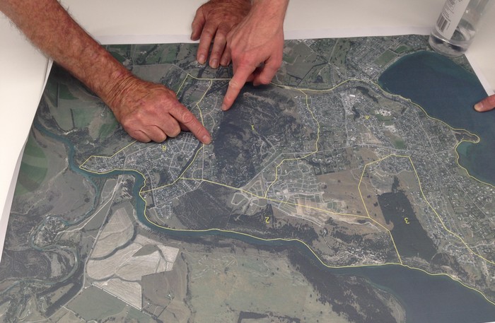
The latest high-resolution climate models overlaid with Scion’s mapping of New Zealand’s growing residential housing in rural areas and on the fringe of urban areas will assist FENZ and other agencies in prioritising community engagement and risk reduction efforts.
The highly detailed climate model simulations describe future wildfire danger projections in every 5x5 kilometre grid cell across the country. This technology has found that climatechange is predicted to ubstantially increase the wildfire risk for many regions, increasing the frequency, severity, and season length of fire weather conditions until at least mid-century.
The magnitude of these risks is linked to the success of climate mitigation efforts, making it important for fire managers to ensure communities become more aware of high wildfire risk environments and communicate knowledge appropriately to successfully prepare and mitigate against wildfires.
Understanding community complexities
Social findings from a community case study and a national survey undertaken by the researchers have enabled fire-related agencies to plan better and use more effective communication methods.
Langer says understanding the level of wildfire comprehension between permanent residents and visitors is essential.
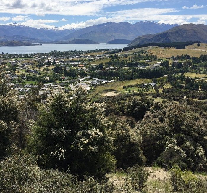
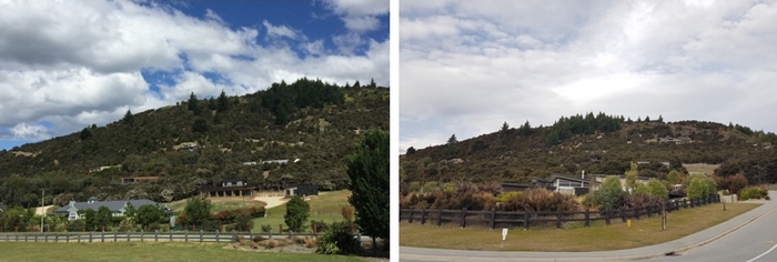
Permanent residents from the small community on the northern side of Wānaka, including Mt Iron, where climate, wild vegetation and development factors have combined to create extreme wildfire risk, were engaged in a case study. This involved interviews, focus groups, and workshops with 64 key end-users and residents to identify wildfire risk awareness and mitigation actions.
Following this, Scion undertook the country’s first national quantitative assessment of wildfire risk perception and mitigation among residents in New Zealand, guided by lessons learnt from the case study.
The case study found that many permanent residents of Mt Iron exhibit high wildfire awareness and anxiety, amplified by the Lake Ōhau wildfire 70km away. Permanent residents also perceived a lack of awareness among short-term residents and tourists who continued to engage in activities such as using braziers and lighting fireworks. This limits the effectiveness of risk reduction efforts carried out by those permanent residents who are aware of the risk and undermines the impact of awareness campaigns by authorities.
Most concerningly, the national survey showed that awareness of and concern about wildfire risk was only weakly correlated with taking action to mitigate risk.
Langer says simple awareness campaigns will not be enough to spur people into action; there are likely to be practical or social barriers to mitigation that need to be addressed.
Wildfire mitigations for homeowners and communities
One of the research components recognised by the EMPA award resulted in 170 best-practice recommendations for agencies, communities, and individuals, supported by international literature to create an easy-to-use resource, Wildfire Mitigations for Homeowners and Communities.
The recommended mitigations have been divided into five categories that apply to people at different stages of preparation and response: building or remodelling a home, landscaping or designing outdoor spaces and property infrastructure, making a wildfire plan, preparing for the start of each wildfire season and when a wildfire occurs.
Recommendations from around the world have assisted fire-related agencies in understanding and categorising wildfires from the early stages when the thought of wildfires has yet to come into planning, right through to a wildfire emergency.
FENZ has developed a Wildfire Safer Housing Guide, which drew on Scion’s house construction recommendations to promote mitigation action among builders and homeowners.
For FENZ Southland, the Mt Iron survey provided useful research data and helped all agencies understand the level of knowledge around wildfire, and the complexities that exist within communities.
Community readiness and recovery advisor Sally Chesterfield says the project identified clear groupings to allow agencies to understand and respond to their different needs.
“The research will be invaluable for measuring the success in reducing wildfire risk and improving resilience from a community and agency perspective in the future.
“It’s data that is usable for all agencies involved in the Mt Iron project and will help to strengthen each agency’s area of responsibility with evidence-based research.”
Extreme wildfire programme launched
Social research has suggested that most engagement surrounding wildfire comes too late, long after housing developments have been designed, homes have been built, and landscaping planted, when substantial changes are complex and costly.
Langer explains that individuals from the Mt Iron community faced challenges like these, with their concerns focused on factors such as restrictions to removing the protected but highly flammable kānuka vegetation around their properties, and the flammability of cedar cladding of their houses.
This community’s difficulties led to a new research direction from preparing and mitigating against future wildfires at an individual property scale to national and local government and developer planning to prepare to live with wildfire.
Now Scion, its international collaborators (US Forest Service, San Jose State University, Karlsruhe Institute of Technology and RMIT) and national collaborators (GNS, Canterbury, Lincoln, and Massey Universities) are undertaking the five-year MBIE-funded Extreme Wildfire programme where one research area is focused on this new direction.
Langer says the Scion team will work with local government and national planners, fire engineers, architects, and landscape architects in a research area focused on preparing to live with wildfire.
“We are investigating how decisions made throughout the planning, design and construction systems lead to wildfire risk to allow broader education which will benefit the wider community. The research will explore how chains of decisions upstream create cascading contexts for decisions at each following step, ultimately shaping community and homeowner wildfire risk.”